Publication Type:
Conference PaperSource:
Vision, Modeling and Visualization (VMV), The Eurographics Association, Volume [to appear], Bayreuth, Germany (2016)ISBN:
978-3-03868-025-3URL:
https://diglib.eg.org/handle/10.2312/vmv20161355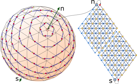
The icosahedral non-hydrostatic (ICON) model is a digital Earth model based on an icosahedral representation and used for numerical weather prediction. In this paper, we introduce icosahedral maps that are designed to fit the geometry of different cell configurations in the ICON model. These maps represent the connectivity information in ICON in a highly structured two-dimensional hexagonal representation that can be adapted to fit different cell configurations. Our maps facilitate the execution of a multiresolution analysis on the ICON model. We demonstrate this by applying a hexagonal version of the discrete wavelet transform in conjunction with our icosahedral maps to decompose ICON data to different levels of detail and to compress it via a thresholding of the wavelet coefficients.